GPS#
GPS receiver.
The
gpsclass models a GPS receiver that measures the inertial position of a vehicle in terms of[x, y, z]. The measurement is affected by a constant bias and sample-to-sample white Gaussian noise.- Parameters:
noise_std (float, optional) – Standard deviation of the position measurement noise, [m]. Defaults to
0.5.bias (array_like, optional) – Constant position bias
[bx, by, bz], [m]. Defaults to[0, 0, 0].isideal (bool, optional) – If
True, overridesnoise_stdandbiasto zero, producing an ideal (noise-free, bias-free) GPS. Defaults toFalse.
Functionality
At each sample the GPS returns a position measurement based on the true inertial position of the vehicle. If the true state is
\[X = [x, y, z, v_x, v_y, v_z, \varphi, \theta, \psi, p, q, r]^T\]the ideal position measurement is
\[z_{ideal} = [x, y, z]^T.\]The simulated measurement is
\[z = z_{ideal} + b + n\]where \(b\) is the constant bias and \(n\) is a zero-mean Gaussian random variable with standard deviation
noise_stdapplied independently to each position coordinate.Errors Model
The GPS measurement is subject to two error sources: bias and noise.
Bias: represents a constant offset in the measured position. It is set when the GPS object is constructed through thebiasparameter and remains unchanged between measurements. Whenbiasis not provided, the bias is[0, 0, 0].Noise: represents random variations in the position measurement. At every call tomeasure, an independent normally distributed random vector with mean zero and standard deviationnoise_stdis added to the position.
The errors model can be disabled by setting
noise_std = 0andbias = [0, 0, 0]. This produces an ideal position measurement.Unlike the
seekermodel, the GPS implementation does not generate a random bias during construction and does not include a scale-factor error. The suppliedbiasis deterministic for a given GPS instance.Construction
A GPS instance is created by making a direct call to the constructor:
>>> gps_sensor = c4d.sensors.gps()
The measurement noise and constant bias can be specified when creating the sensor.
Examples
Import required packages:
>>> import c4dynamics as c4d
>>> from matplotlib import pyplot as plt
>>> import numpy as np
True trajectory
For the examples below, generate a smooth 3D trajectory and store its position in a 12-state vector.
>>> t = np.arange(0, 20, 0.1)
>>> x_true = np.zeros((len(t), 12))
>>> x_true[:, 0] = 5 * np.sin(0.3 * t)
>>> x_true[:, 1] = 4 * np.cos(0.25 * t)
>>> x_true[:, 2] = -2 + 0.5 * np.sin(0.6 * t)
Ideal GPS
An ideal GPS can be created by setting both the noise and the bias to zero:
>>> gps_ideal = c4d.sensors.gps(noise_std=0, bias=[0, 0, 0])
>>> measurements = np.array([gps_ideal.measure(x) for x in x_true])
The measured position is then identical to the true position.
>>> np.allclose(measurements, x_true[:, 0:3])
True
Non-ideal GPS
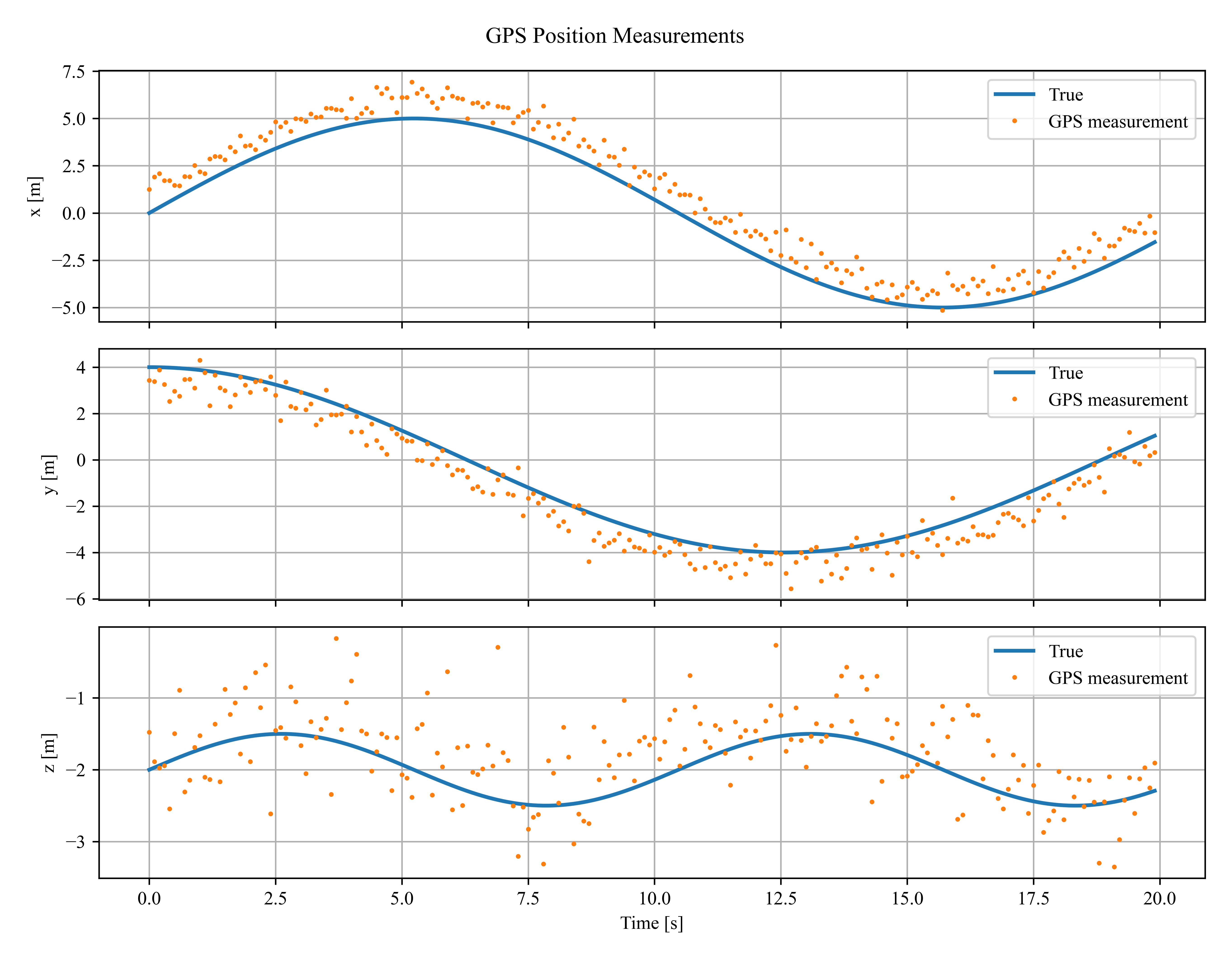
A non-ideal GPS introduces a constant position bias and white measurement noise. Set the random seed to make the example reproducible:
>>> np.random.seed(42)
>>> gps_sensor = c4d.sensors.gps(
...     noise_std=0.5,
...     bias=[1.0, -0.5, 0.2]
... )
>>> measurements = np.array([gps_sensor.measure(x) for x in x_true])
The result can be compared with the true position:
>>> fig, ax = plt.subplots(3, 1, figsize=(9, 7), sharex=True)
>>> labels = ['x', 'y', 'z']
>>> for i in range(3):
...     ax[i].plot(t, x_true[:, i], lw=2, label='True')
...     ax[i].plot(t, measurements[:, i], '.', ms=3, label='GPS measurement')
...     ax[i].set_ylabel(f'{labels[i]} [m]')
...     ax[i].grid(True)
...     ax[i].legend()
>>> ax[-1].set_xlabel('Time [s]')
>>> fig.suptitle('GPS Position Measurements')
>>> fig.tight_layout()
Bias
The bias is constant across all measurements. For example, a GPS with a 2m bias in the x direction can be created as follows:
>>> gps_bias = c4d.sensors.gps(noise_std=0, bias=[2, 0, 0])
>>> measurement = gps_bias.measure(x_true[0])
>>> print(measurement - x_true[0, 0:3])
[2.  0.  0.]
The difference between the measurement and the true position is the specified bias.
Measurement noise
With zero bias, repeated measurements of the same state demonstrate the random noise generated at every call to
measure:>>> np.random.seed(1) >>> gps_noise = c4d.sensors.gps(noise_std=0.5, bias=[0, 0, 0]) >>> for _ in range(3): ... print(gps_noise.measure(x_true[0])) [ 0.812 3.694 -2.264] [-0.536 4.433 -3.151] [ 0.872 3.619 -1.840]
Demo
The built-in
demomethod provides a compact demonstration of the GPS errors model and plots the true and measured positions:>>> fig = c4d.sensors.gps.demo(show=True)
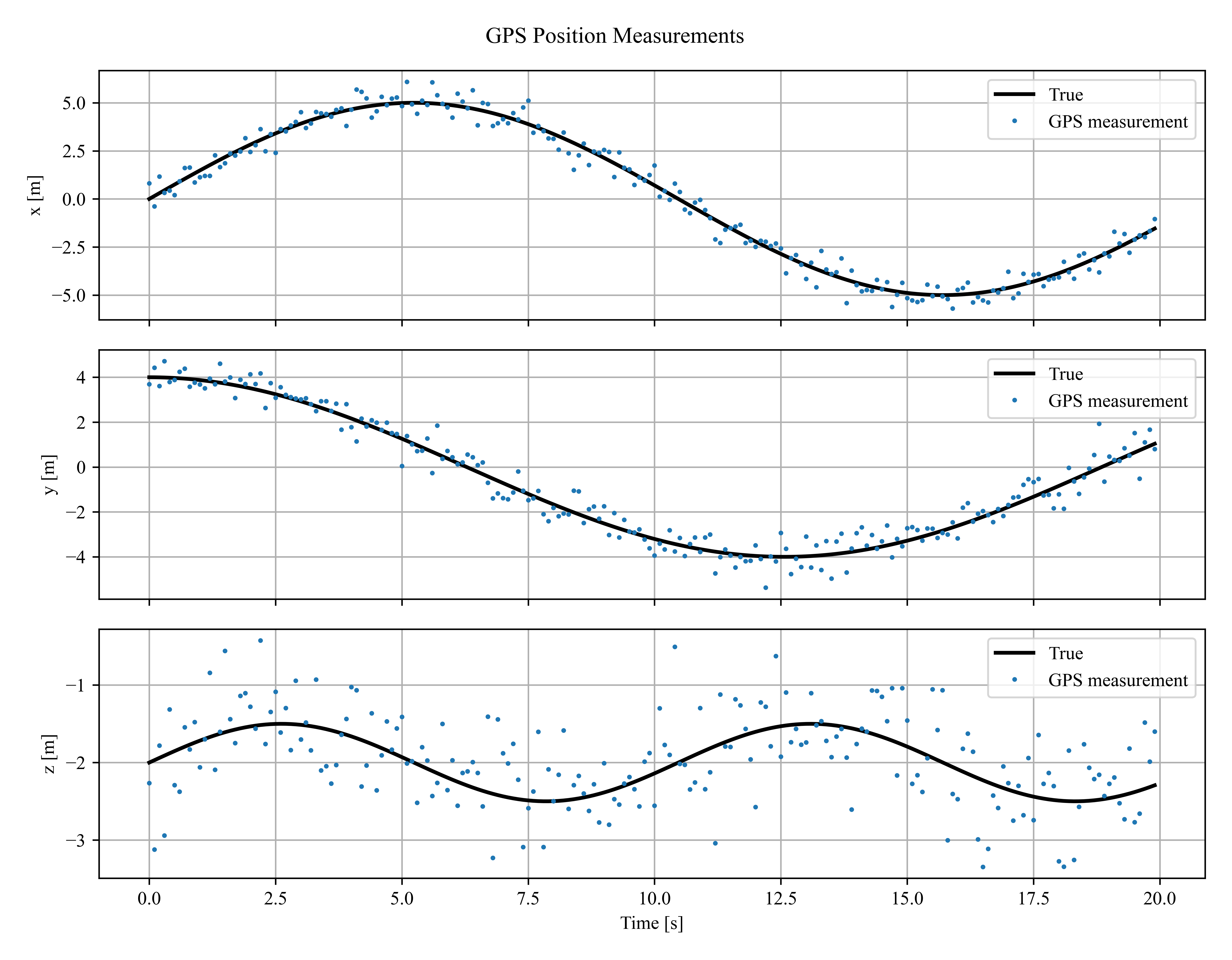
The same demonstration can be run without displaying the figure by using
show=False.Methods
gps.measure(x_true)Measure inertial position.